American Trails sponsors an annual photo contest for photographs of National Recreation Trails. Contest details for 2009 are at the American Trails Photo Contest page. These are the photos I sent for 2009. The idiosyncratic selection of trails was driven by the rules -- only designated National Recreation Trails are eligible.
The winning photos are at the top, followed by other photos from the Great Allegheny Passage, the Allegheny River Trail system, the Ghost Town Trail, the Montour Trail, the Lower Trail, the Roaring Run Trail, the Staple Bend Trail, the West Penn Trail, the Cuyahoga Valley Towpath, and Erie Canal Heritage Trail.
Trail Features Category: Arts and Interpretation |
 |
Eastern Continental DivideGreat Allegheny Passage at the Eastern Continental Divide east of Meyersdale PA The new extension of the Allegheny River Trail on the west side of the Allegheny River |
||
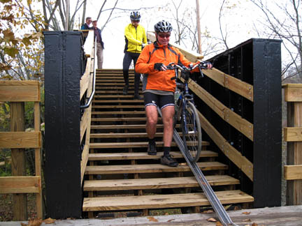
Trail Features Category: Innovative Facilities |
 |
Stairs up Bow RidgeWest Penn Trail, Conemaugh Lake, east of Saltsburgh PA The active railroad runs alongside the interurban line that has been converted to the trail |
||
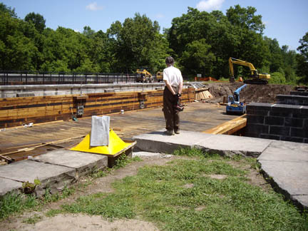
Trail Features Category: Historic Features |
 |
Canal Locks in SaltsburgWest Penn Trail, Saltsburg PA This historic 135-year-old cast-iron Bollman bridge once carried the B&O railroad over Wells Creek. It has been moved to carry the Great Allegheny Passage over Scratch Hill Rd. The approaches to the bridge are still under construction, and the trail community eagerly anticipates the finishing touches
|
Allegheny Highlands segment in Pennsylvania |
|
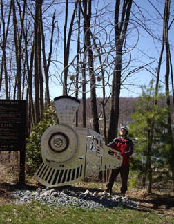
Train art at RockwoodThe Rockwood trailhead of the Great Allegheny Passage features this sculpture, which celebrates conversion of the railroad grade to a bicycle/pedestrian trail. |
||

|
FossilsThe Wymps Gap fossil bed emerges beside the trail.
|
|||
| Steel Valley segment |

|
Riverton BridgeThe challenge of a safe trail crossing of the Monongahela River near McKeesport was resolved by rerouting the little remaining traffic that used the Riverton Bridge, abandoning the bridge for railroad use, and converting the bridge for trail use.
|
||
 |
Riverton BridgeThe challenge of a safe trail crossing of the Monongahela River near McKeesport was resolved by rerouting the little remaining traffic that used the Riverton Bridge, abandoning the bridge for railroad use, and converting the bridge for trail use. Photo by Roy Weil |
|||
|
|

|
Sharing the route at DuquesneThe trail parallels the Norfolk Southern mainline between the Riverton Bridge and McKeesport. When this flyover was recently constructed as part of an industrial park development, special provision was made for the trail to go through one of the abutments
|
||
 |
Trail at The WaterfrontThe path runs between the condos and the Mon River at The Waterfront. Photo by Roy Weil
|
|||
| Three Rivers Heritage segment |

|
Hot Metal BridgeTwo near-identical railroad bridges share a single set of piers. The Monongahela Connecting RR bridge on the left once carried general rail traffic and was converted for vehicle use. The Hot Metal Bridge on the right was used to shuttle hot metal from the Pittsburgh Works furnaces to the South Side Works rolling mills; it was converted for bike/ped use. Because of the strategic concentration of rail traffic and steel production, this pair of bridges was the nations’ highest-priority bridge for protection from enemy attack during World War II
|
||

|
Pittsburgh at Night in Station SquareStation Square is a shopping and restaurant complex in the former P&LE Railroad Station across the Monongahela River from downtown Pittsburgh. It features a “dancing fountain”, which was brilliantly lit on Light Up Night. The trail is just the other side of the fountain from this view.
|
|||

 |
Pittsburgh at Night from Hot Metal BridgeThe Hot Metal bike/ped bridge offers one of the greatest views of Pittsburgh to be had anywhere in the city. Each year the city celebrates the start of the holiday season with “Light Up Night”, and most office buildings keep their lights on to brighten the festivities. Bicyclists join the celebration with rides around the city. These two views from the Hot Metal Bike/Ped Bridge were taken on Light Up Night 2009.
|
|||
Youghiogheny River Trail segment
|
 |
Autumn on the YoughIn early autumn the trail is covered in leaves. |
||
|
|
 |
DiamondbackAlthough it is not common, you may see rattlesnakes near the trail. |
| Allegheny River Trail |
 |
Descending from Sandy CreekTrailSandy Creek Trail crosses the Allegheny River on the historic Belmar Bridge. The Allegheny River Trail runs along the bank of the Allegheny River. These stairs provide a connection between the two trails.
|
||
 |
Parcourse at Franklin TrailheadIn western Pennsylvania, parcourses with exercise stations are common features of trails
|
|||
 |
Campground by Allegheny RiverThe Allegheny River Trail offers ample camping between the trail and the river. This site provides an Adirondack-style shelter
|
|||
 |
WaterfallWaterfall near the entrance to one of the tunnels on the trail.
|
|||


 |
Interpretations of a Stone Arch BridgeA stone arch bridge near the trail offers inspiration for abstract treatment.
|
|||

 |
Interpretations of a Tunnel EntryA tunnel entry offers inspiration for abstract treatment |
|||
| Samuel Justus Traill |
 |
Donkey EngineThe oil industry was born in this region, and oil is still produced here. Several of these donkey engines beside the trail extract oil from small wells
|
 |
Anticipation: Bridge Construction near DilltownContinuity of the Ghost Town Trail has been interrupted by two missing bridges west of Dilltown, which were washed out in a flood. Summer 2009 saw reconstruction of those bridges |
|
|
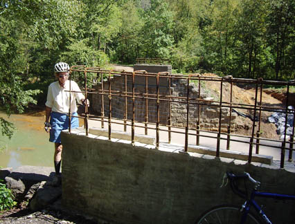
Safety Improvement at Venice CrossingThe Montour Trail, otherwise continuous for many miles in both directions, is interrupted at this intersection by a missing bridge. The trail continues to both ends of the demolished bridge, but the bridge is 15 feet above the road. Trail travelers have been forced to detour for a half mile along busy PA50. An all-volunteer project of the trail group reduced the hazards for trail users by installing a stairway from the old bridge down to the side of the road. The slope of the stairs and a wheel trough provide easy passage for bicyclists |
||
|
|
Campground near HendersonvilleThe Montour Trail provides a route from the Great Allegheny Passage to the west, and eventually to Pittsburgh Airport. The trail has created a group of campsites near Hendersonville to support self-contained bicycle tourists |
||
|
|
Stone Arch BridgeThis handsome stone arch bridge carries the trail over Fox Fun. It also provides inspiration for an abstract view of the bridge in autumn.
|
||
|
|
Mt Etna Covered BridgeThis covered bridge crosses a mill race near the Mt Etna access area
|
||
|
|
Bridge on Roaring Run TrailA bridge at the mouth of a small side creek rises high to provide passage for high water. |
||
|
|
Suspension Bridge over Roaring RunA spur trail runs up Roaring Run. Until this suspension bridge was built, trail users had to ford the stream here.
|
||
|
|
Acid Mine Discharge RemediationThe Trux Mine was once one of the worst abandoned mine water discharges in Pennsylvania, with mine water cascading down this slope and coating the bank with bright orange sludge. A remediation project is capturing the sludge, leaving a stable hillside that supports vegetation.
|
||
|
|
Staple Bend TunnelThis is the oldest railroad tunnel in the United States. Until the trail was built, it was rarely accessible to the public |
||
|
|
Stone Sleepers on Allegheny Portage RROne of the historic features of the Allegheny Portage Railroad was the use of stone sleepers instead of wooden ties. This row of sleepers is visible beside the trail |
||
|
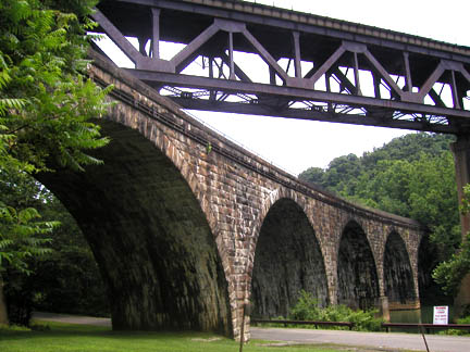
Stone Arches over Conemaugh LakeWhen the Corps of Engineers built a flood control lake here half a century ago, the railroad was relocated to higher ground. The stone bridges that formerly carried the railroad over the valley now carry the West Penn Trail |
|||
|
|
Stone Arches over Conemaugh RiverBelow the flood control dam, the original arch bridges emerge from a tunnel that is now closed; bicyclists must go over the ridge that the tunnel goes through. The relocated railroad crosses over the original stone bridge, which carries the trail over the river here |
||
|
|
Lock DemonstrationThe visitor’s center offers demonstrations of a restored lock |
|
|
WetlandsThe towpath passes through a wetlands on a boardwalk |
|
|
Old and New at LockportThe original canal had two flights of five locks, one for passage in each direction. One of these remains; the other has been replaced by a single modern deep lock |
|
|
Nine Mile Run Aqueduct under RestorationThis aqueduct is being restored. When it is finished, it will be the only restored navigable aqueduct in New York State |
||
Up to Mary Shaw Home
Electronic mail: mary [at] shaw [dot] org
Sorry, but I can't put a mailto link in here because the
spammers will harvest it. To contact me, edit the pieces together
in the obvious way.
Snail mail: Shaw-Weil Associates, 414 South Craig St PMB 307, Pittsburgh PA 15213
Copyright © 2003 by Mary Shaw. Use of any portion of this site to generate spam or other mass communication is forbidden. Last revised: June 14, 2010.